Protect Our Watershed
Water systems connect everything in this landscape. Industrial-scale land conversion puts those connections at risk.
Water Is a Shared System
Watersheds don't follow property lines. What happens upstream affects everything downstream.
- Interconnected by design. Creeks, groundwater, wetlands, and seasonal flows form a single hydrological system. Forest cover regulates how water moves through it — filtering, slowing, and storing runoff.
- Impacts are not isolated. Converting recovering land and compacting soil at one location changes water flow, sediment load, and infiltration rates across the broader watershed.
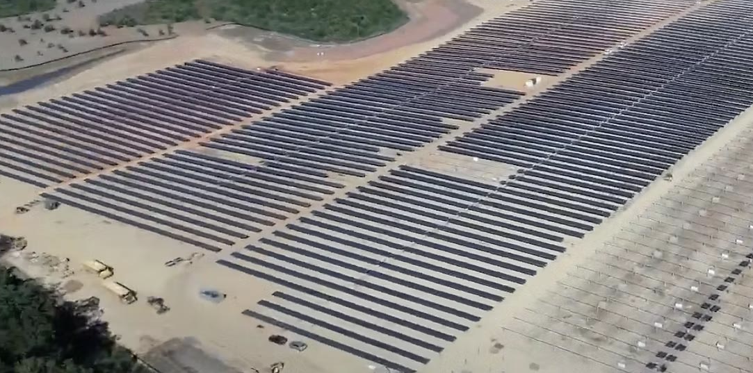
- Cumulative effects matter. Even if a single intervention appears manageable, the combined impact of roads, grading, fencing, and panel installation across a 776-hectare project area compounds downstream — especially with two construction phases planned.
Scale of Development
The proposed footprint is not a minor land-use change.
Real-World Example: Guichon Creek
Guichon Creek is an example of a water source that is actively used on the ground — and may be more significant than official descriptions suggest.
- Supports livestock operations. Local ranchers rely on Guichon Creek and its tributaries for watering cattle on range tenures. This is active, ongoing use — not historical or theoretical.
- Not simply seasonal. While flow varies, the creek system provides water across seasons and supports downstream users who depend on consistent supply.
- Classification may understate importance. Formal environmental documentation sometimes classifies watercourses in ways that don't reflect their real-world significance to people and operations on the ground.
"What appears minor in documentation may be critical in practice."
Accurate environmental assessment depends on understanding how water is actually used — not just how it's classified.
Risk Pathways
Industrial-scale land conversion introduces multiple risks to water systems.
Sediment Runoff
Converting a significant portion of the 776-hectare project area removes regenerating root systems that stabilize soil. Rain events carry sediment into streams, degrading water quality and aquatic habitat.
Drainage Pattern Changes
Grading and compacting land for panel installation alters natural drainage. Water that once percolated through forest soil is redirected as surface runoff.
Contamination Risk
Panel cleaning agents, transformer oils, and battery storage chemicals present ongoing spill risks over a multi-decade operational period.
Fire-Related Impacts
Industrial infrastructure in a fire-prone landscape creates ignition risk. Post-fire runoff from cleared land carries contaminants into downstream water systems.
Long-Term Impact
This is not a temporary disruption. Industrial solar infrastructure occupies land for decades.
- Multi-decade presence. With Phase I targeting 2030 and decommissioning or repowering around 2060, the land is unavailable for any other use — forestry, recreation, or watershed protection — for a generation.
- Ongoing exposure. Throughout operation, stormwater management, equipment maintenance, and chemical handling present continuous low-level risks to surrounding water systems.
- Decommissioning unknowns. There is no established precedent in BC for decommissioning industrial solar at this scale. Who bears the cost? What condition is the land left in? These questions remain unanswered.
What This Means for the Community Forest
Watershed impacts don't stop at project boundaries. The Community Forest is directly downstream of consequence.
Sets a Precedent
Allowing industrial development adjacent to the Community Forest creates precedent for future encroachment on public land.
Redefines Land Purpose
Public forest managed for community benefit becomes buffer land for private industrial infrastructure.
Reduces Community Control
Once land-use decisions are made at the provincial level, local governance and community input are diminished.
Take Action on Water Protection
The Environmental Assessment process is the formal mechanism for raising watershed concerns. Your input matters.
Key Points for Your EA Submission
- Request a comprehensive hydrological assessment covering the full watershed, not just the project footprint.
- Ask for documentation of all active water use — including livestock, domestic, and agricultural — along Guichon Creek and tributaries.
- Raise concerns about long-term sediment, drainage, and contamination risks across a multi-decade operational period through ~2060.
- Request clarity on decommissioning plans and financial guarantees for site restoration.